Access and staging
Defined work zones, traffic arrangements and pedestrian routes supported staged construction within the urban corridor.

SCE project profile
A staged civil drainage project combining trench excavation, stormwater-line installation, pit upgrades, utility coordination and pavement reinstatement in West Ryde.
Project scope
The West Ryde works form part of Farshid MANESH’s wider career experience, contributing to the civil engineering, estimating, construction planning and operational leadership he brings to SCE. The project included excavation, trenching, new stormwater lines, reinforced concrete pit works, utility relocation and pavement reinstatement.
Delivery was staged around existing roads, footpaths, utilities and drainage flow paths. The work sequence combined civil construction activities with traffic, pedestrian and environmental controls.
Delivery controls
Defined work zones, traffic arrangements and pedestrian routes supported staged construction within the urban corridor.
Quality controls included survey set-outs, hold points, density testing, CCTV inspection and closeout documentation.
Sediment, dust and dewatering controls were applied to suit the site conditions and work sequence.
Project photographs
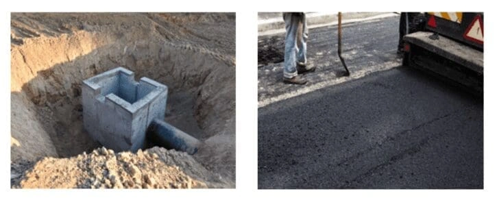
The project photographs show a stormwater pit in the excavated work area and the reinstated pavement surface after civil works.
The image shows the drainage construction and reinstated pavement, illustrating how below-ground works and surface restoration were delivered together.
Related projects and services
Review related SCE project pages covering civil infrastructure delivery.
View Civil Infrastructure ProjectsSee the Epping–Thornleigh project profile for related stormwater and civil-works experience behind SCE.
View Epping–Thornleigh Stormwater WorksExplore SCE civil construction services and project delivery experience.
Explore Civil ServicesYou can also review the SCE System or return to the SCE Projects directory.
Frequently asked questions
The scope included pavement removal, trench excavation, stormwater-line installation, pit upgrades, utility coordination, traffic controls and pavement reinstatement.
The project involved new stormwater lines, reinforced concrete pit works and upgrades to existing stormwater pits.
The project involved stormwater lines up to 1300 mm in diameter.
The works used staged work zones, traffic arrangements and pedestrian routes used to maintain access around the civil works.
Utility coordination and relocation formed part of the scope so the drainage works could proceed through the active corridor.
Quality controls included survey set-outs, hold points, density testing, CCTV inspection and closeout documentation.
The image shows a stormwater pit within the excavated work area and pavement reinstatement after the civil works.
Use the SCE contact page to share the location, known drainage scope, access constraints, existing services and required project timeframe.
Plan the next step
Share the location, known scope, access constraints and available site information so SCE can understand the project context.